

After a decade of sporadic development, an in-depth federal map of corridors and facilities critical to multimodal freight transport in the US is closer than ever to completion. But it's unclear whether the map, formally known as the National Multimodal Freight Network, will come to fruition now that its fate is in the hands of the Trump administration.
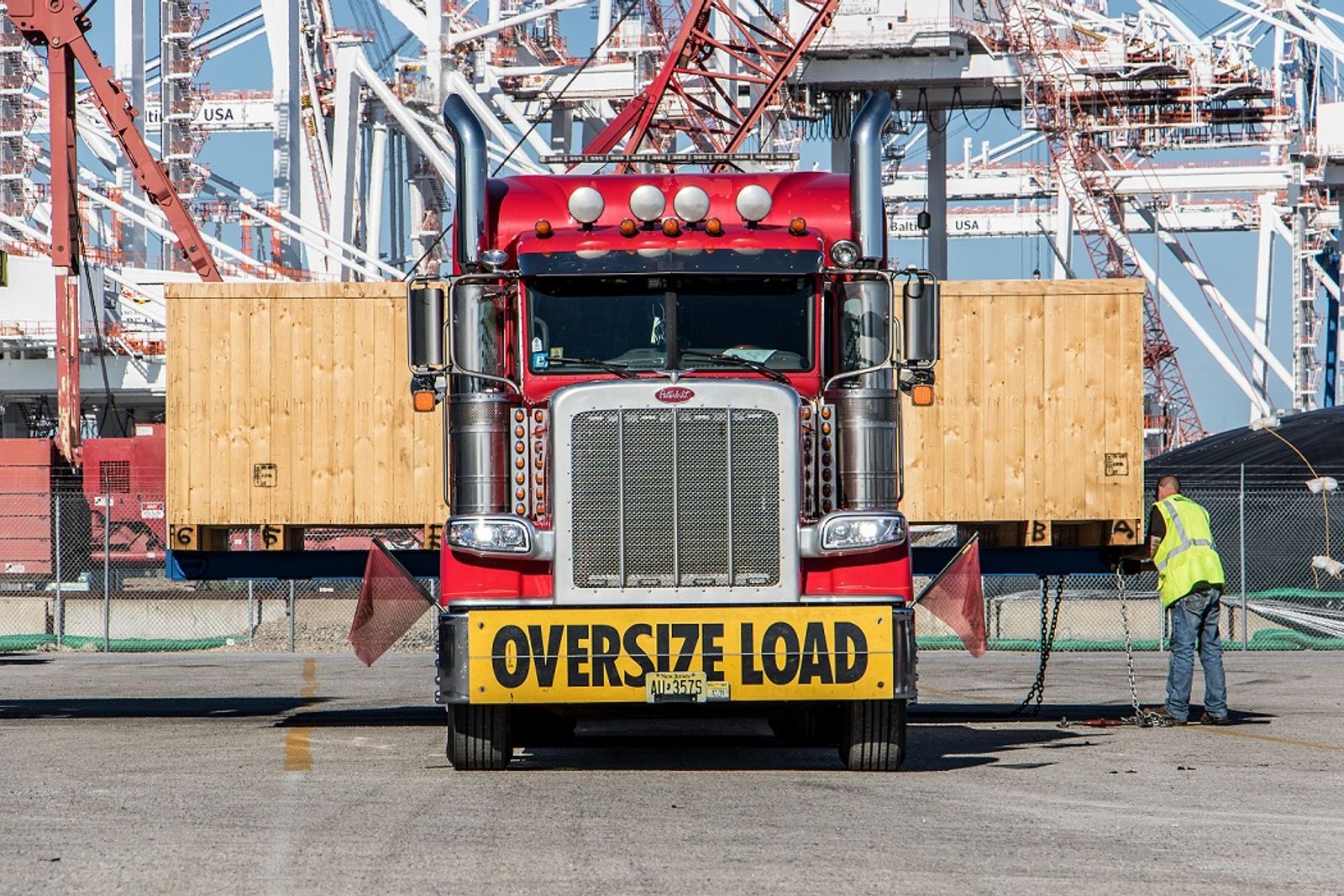
With those efforts in question, heavy haulers with a stake in the multimodal network are forging ahead with their own push for processes, highway improvements and infrastructure specific to the transport of oversized and/or overweight (OS/OW) loads that carry breakbulk and project cargo over land.
“The continuing message is: Don't forget the oversized-overweight segment. If a state is going to be looking at corridors for freight, remember that our industry is out there as well, and we're going to need some slightly different accommodations on those highway networks,” Chris Smith, transportation vice president for the Specialized Carriers & Rigging Association (SC&RA), told the Journal of Commerce.
Creation of the network was scheduled to advance to the final stages this spring, although that timeline was set during the final days of the Biden administration.“I think uncertainty is the word of the day,”Smith said.
After failed attempts by the Obama and previous Trump administrations to establish the network, the Biden administration revived those efforts in late 2023.
On Jan. 13, a week before Donald Trump took office, the US Department of Transportation published a draft version of its National Multimodal Freight Network map, informed by public comments the department solicited in April 2024.
The draft was signed Jan. 6 by Allison Dane Camden, the then-principal deputy assistant secretary for multimodal freight under the US Department of Transportation (US DOT). Camden, who was tapped by the Biden administration to oversee the network's development, has since left the agency. The US DOT did not respond to a request for comment from the Journal of Commerce.
The draft network consists of 175,000 miles of highways, railways and waterways, along with 205 marine ports and airports designated as critical to freight movement and global and domestic supply chains.
US DOT opened up the draft for public comments through Feb. 27 with plans to designate the network in spring 2025. Once designated, the network could be used to inform decision-making and investment priorities at the federal, state and local levels.
When tying freight corridors to ports, industrial parks and intermodal centers, Smith said both federal and state corridor mapping should factor in the needs of heavy-haul transport.
“The economic impact of the things our segment carries far outpaces the volume,”he said.“But there are some special needs that come with that.”
Oversized parking problem
Establishing a network of critical multimodal corridors could help remedy a perennial challenge for heavy-haul truckers — the need for more rest stops that can accommodate oversized loads, as some rest areas restrict them.
Smith cited a concerted effort by USDOT to address the shortage of parking for cargo trucks, especially in urban and high-traffic areas. Finding enough space for container trucks and standard-size hauls presents a challenge in and of itself, but factoring in heavy-haul vehicles and loads adds another layer of complexity.
“Oversized, overweight permanent loads often run on local and state highways, not on the interstate,”Smith said.”So if all the rest stations are on the interstate, that's a problem.”
John Welch, general manager of heavy-haul and wind operations for Fort Worth-based Lone Star Transportation, told the Journal of Commerce that developing such a map could help governments pinpoint where to locate rest areas, while giving commercial developers insights into where to build truck stops.
“I would hope that would encourage the Flying Js, the Pilots, the larger truck stops to start putting their facilities along those corridors,”he said.
Welch said federal mapping could also help government entities prioritize which corridors are in need of improvements.“I think this network would be great, especially if these roads were continually funded by federal grants so they're constantly being repaired and upgraded,”he said.
Preserving the existing corridors that heavy haulers rely on is another concern for OS/OW transporters. Craig McGraw, vice president of sales and marketing for New Jersey-based carrier Trans American Trucking & Warehouse, told the Journal of Commerce that the addition of roundabouts makes it more difficult for oversized loads to maneuver.
“All the heavy-haul routes are in place for a reason,”he said.“So our big push was just to keep everything the way it is with that.”
Roundabouts can make things particularly challenging when transporting massive components such as wind turbines, Welch said.
“A route that would be good for a general 13-axle heavy load would not necessarily be good for the blades,”he said.“We could not get most of our blades into and out of most of the ports around the greater Houston area.”
Welch added that he's seeing larger blades being sent to Corpus Christi and Brownsville instead because that's where the infrastructure can accommodate them.
States stepping up
Independent of federal efforts to develop mapping for multimodal freight, the heavy-haul segment has made a push over the last decade for improved synchronization among state transportation departments when it comes to OS/OW transport requirements, as well as automated permitting systems for each state.
Permitting and regulations vary from state to state, and there are often additional, overlapping requirements set by county and municipal governments.
In 2018, SC&RA rolled out an initiative encouraging states to implement an automated system that would make the issuance of permits available electronically 24 hours a day, seven days a week — eliminating the need for human review in most cases.
At the time, there were 36 states with some level of automation. Since then, Alaska and Wyoming have joined the ranks, launching fully automated systems in 2024, while Connecticut and Oregon have systems in development, Smith said.
“So, we're down to a handful of states that don't have it yet,”he said.
According to a Journal of Commerce analysis of SC&RA data, only seven states and the District of Columbia have indicated no interest in using an automated permitting system. The states are Alabama, California, Delaware, Hawaii, Michigan, South Carolina and Vermont.
Should the Multimodal Freight Network move forward this spring, states would have a specific role to play in developing it. Each state would have at least 180 days to propose route additions of up to 30% of the total mileage designated in that state.
Following US DOT's April 2024 request for information, the agency received 43 written responses from shippers, carriers, port authorities, state DOT representatives, metropolitan planning organizations, railroads and community interest groups.
Among them was the American Association of State Highway and Transportation Officials (AASHTO). On Feb. 25, the association submitted a letter to US DOT Secretary Sean Duffy urging the department to finalize the multimodal network map.
“Our supply chains have been tested significantly in recent years, and we strongly advise that the completion of this framework will serve as a vital tool for improving freight transportation infrastructure,”the organization wrote.
Regardless of whether the Multimodal Freight Network moves forward, Smith said there are indications that efforts to meet the needs of heavy haulers will continue to advance.
“I do think there's a sense that this administration will ultimately be more friendly to commerce and trade,”he said.